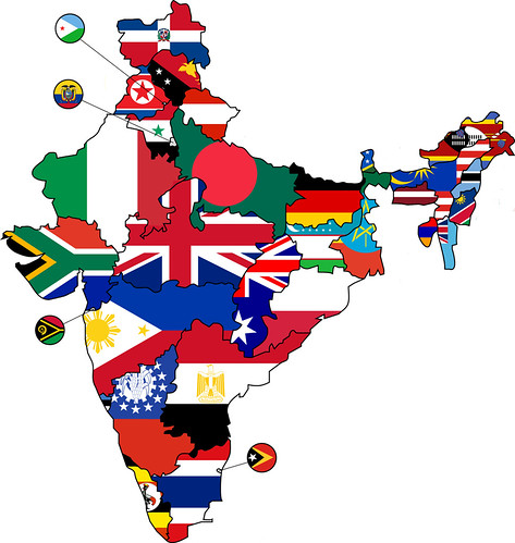
I've been reading a lot about India in preparation for an upcoming trip. Even though I know, like everyone else, that the nation's total population is about 1.3 billion, I'm still astounded every time I read about how many people live in a given state. Inspired by this map, which replaces the US states with the flags of countries of equal population, I created the map above. As in the United States map, each state or territory is represented by the flag of the country whose population is roughly equivalent to that of the state. I took a few liberties, such as omitting the smaller union territories and leaving out the boundaries that are disputed by India and its neighbors.
Here are a few unexpected things that showed up in the map:
- The state of Gujarat is closest in population to South Africa. Gandhi, who was born in Gujarat, spent over two decades in South Africa before returning to India.
- Because Madhya Pradesh and Chhattisgarh are represented by the UK and Australian flags, respectively, they appear at first glance to be connected. In fact, Chhattisgarh split off from Madhya Pradesh in 2000 to become its own state, so the connection is appropriate.
- The flags of Swaziland, Botswana, and Namibia, real-life neighbors in southern Africa, here represent the adjacent northeastern states of Arunachal Pradesh, Nagaland, and Manipur (though it can be hard to tell because the northeast's already-crazy jumble is made more confusing by multicolored flags).
- The state of Haryana, here represented by the flag of Syria, is shaped a lot like Iraq, whose flag looks a lot like that of Syria.
No comments:
Post a Comment